Using a Sectional to figure out where to fly your drone
I love maps, aviation, and photography, so planning for a drone flight combines a lot of my favorite things. Drones are obviously fantastic for aerial landscape photography, but I also like to play with aerial portraiture. I'm surprised there aren't a lot more people doing it. I've taken some bird’s-eye pictures with my DJI mini 3 pro with great results.
Planning a flight is critical for safety, because the last thing we want to do is harm people, property, or worse, flying aircraft.
Maps of how Federal airspace is designated are critical for planning, so let's go over how we can use one of these maps to find good places to fly, and which places are off limits.
Remember, there's no substitute for your own due diligence. When you prepare to fly you'll need to check official and up-to-date airspace sectionals, weather reports and local ordinances.
Simplifying the Sectional
Here is the sectional map over Massachusetts. It's designed to show pilots how all of the airspace in a given area is allocated. With a drone we're only concerned with the airspace nearest the ground. Specifically the up to 400 ft above ground level, which is the upper limit for a part 107 qualified drone pilot.
Figure 1. Ground-level airspace in Massachusetts using the New York Sectional.
There are areas where a lot of air traffic is near the ground like at an airport. The busiest of these are the class B airspace at large airports like Logan International. That's the blue circle with a solid line in Figure 1. Medium sized class C airports are in a brown circle with a solid line, and smaller airports like Beverly Regional are in class D. Those are blue with a dashed outline. Smaller airfields without air traffic control all generally in class E. And it's possible that class E space will be at surface level close to the airport. The rest of the time class e aerospace is either at 700 or 1,200 ft above ground level. With everything below being uncontrolled class G airspace .
Figure 2. Ground level airspaces combined with Google Maps.
I've marked out these ground level airspaces and used Google Maps (Figure 2) as an underlay rather than the complicated sectional. If a section is overwhelming for you, then a map like this will be easier to look at. You can see the near ground level air spaces relative to the towns roads and water features that you are familiar with on a map.
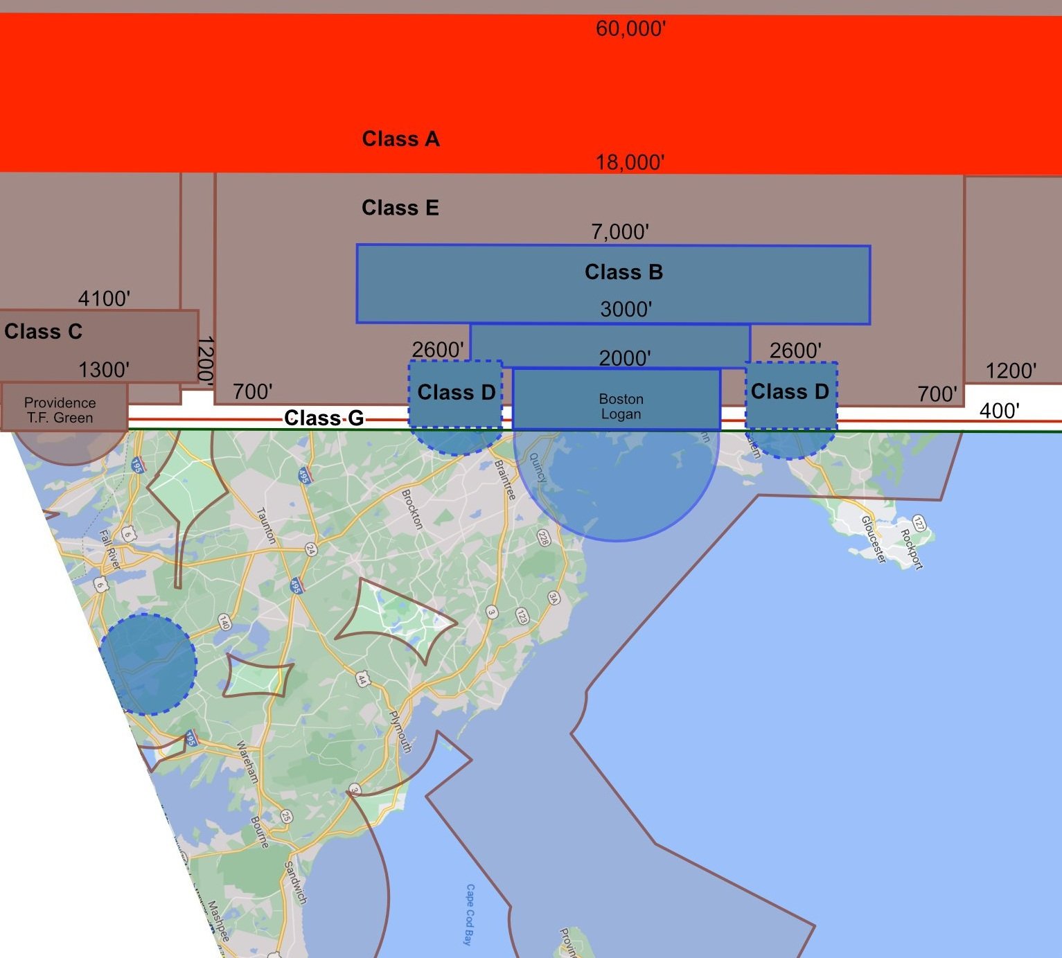
Figure 3. I rotated the map to draw a vertical cross-section of the airspace.
I find that making a cross-section helps in visualize the airspace drawn on the sectional. In the example in Figure 3 I've drawn a line from Providence to Newburyport as a base for a cross-section showing how the airspace looks vertically. Drones are usually restricted to 400 ft above ground level - I drew that on as a red line to show the tiny slither of airspace drones have access to in the grand scheme of things. There is usually a buffer of 300 or 800 ft between the drone zone and the lowest that manned aircraft can fly in class E airspace. It is possible for manned aircraft to fly lower than this, under class E, but in general they are limited to a lowest elevation of 500 ft above ground level (obvious exceptions would be light recreational aircraft and helicopters).
In central Boston there is the large surface area of class B airspace at Logan international, and a few class D areas at ground level for smaller airports. It is possible to fly in these areas with special permission. But generally we are restricted to windows beneath class E areas like Salem and Marblehead and further up the North Shore of Boston, west of Newton and south of Braintree.
The FAA have sectionals covering the entire USA. And you can find the sectional for your area through on the FAA's website using this link.


